United States Karst Aquifer Map
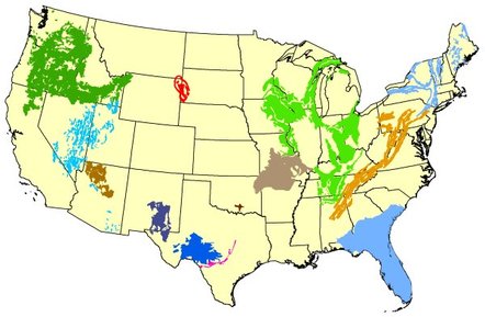
Karst is a type of landscape, and also an aquifer type. Karst areas consist of solid but chemically soluble rock such as limestone.
These aquifers include valuable freshwater resources, but are sometimes difficult to exploit and are almost always vulnerable to contamination, due to their specific hydrogeologic properties.
Karst aquifers are also highly vulnerable to water contamination due to their fast transport rate and limited ability to filter water.
http://water.usgs.gov/ogw/karst/aquifers
http://water.usgs.gov/ogw/karst/kigconference/cjt_quantitative.htm
Aquifers and Groundwater
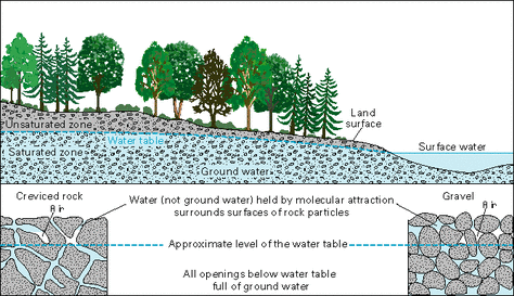
Half of all Americans and more than 95% of rural Americans get their house-hold water supply from underground water sources via wells. Ground water is also used for much of our nation's agricultural and industrial water needs.
Groundwater is part of the continuous hydrological cycle in which water moves between Earth and the atmosphere via precipitation, evaporation, and transpiration. Precipitation falls to Earth and some of the water runs off the surface into streams and rivers, some is absorbed by plants, some evaporates, and some soaks into the ground. The water that soaks into the ground moves downward into the water table- an area of water saturated rock and soil.
Water in this saturated zone is called groundwater. Areas where there is enough water to supply wells and springs are called aquifers. These aquifers store water in the spaces between particles and in cracks in the rocks. There are two kinds of aquifers: confined and unconfined. A confined aquifer is often deeper and is protected by relatively impermeable materials such as clay, shale and unfractured bedrock, and is more protected from contamination. An unconfined aquifer is not protected by impermeable material and may be closer to the surface, thus more easily contaminated by surface water runoff. Wells that reach the deeper confined aquifers are less likely to be contaminated with runoff water.
http://www.safewater.org/PDFS/resourcesknowthefacts/Groundwater.pdf
http://water.epa.gov/type/groundwater/
Karst
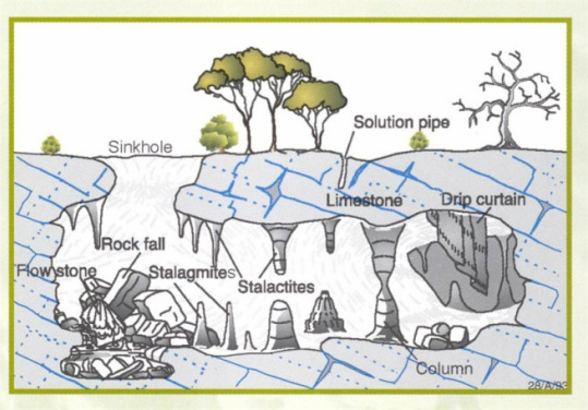
What is Karst?
Karst is a terrain with distinctive landforms and hydrology created from the dissolution of soluble rocks, principally limestone. Karst terrain is characterized by springs, caves, sinkholes, and a unique hydrogeology that results in aquifers that are highly productive but extremely vulnerable to contamination.
Northwestern Arkansas is well known for its karstic features. Karsitc features include sinkholes, conduit springs, and large caves. A sinkhole is an oval shaped depression that is formed from the dissolution of carbonate bedrock. These sinkholes are important because this is where water recharge enters the aquifer directly. Recharge through sinkholes can reach extreme volumes.
Springs are also a major aspect of the aquifer system. Springs are where discharge from the aquifer flow to the surface and emerge out onto the surface of the land. Many of these springs are located on the sides of steep valleys. Another feature of this area are the caves. There are thousands of caves in northern Arkansas. In Missouri, karst can be noticed in the southern section of the state and these areas area also susceptible to contamination through karst features.
http://water.usgs.gov/ogw/karst/index
http://academic.emporia.edu/schulmem/hydro/TERM%20PROJECTS/2008/Thomas/Project.index.html
